
Kaziranga's One Kilometre: Why the Buffer Debate Is Being Argued in the Wrong Currency
"কাজিৰঙা, কাজিৰঙা... ই ভয়াবহ নহয়, নহয় অভয়াৰণ্য ইয়াতকৈও ভয়াবহ জানা, পৃথিৱীৰ জন-অৰণ্য” “Kaziranga, Kaziranga… it is not the sanctuary of creatures that should strike dread into our hearts, nor the consecrated forest of protection. More formidable still, more perilous beyond measure, is the boundless human jungle that engulfs the earth.”
Advertisement
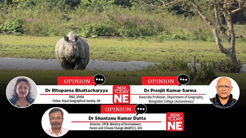

Rituparna Bhattacharyya / Dr. Pranjit Kumar Sarma / Dr. Shantanu Kumar Dutta
- Aug 23, 2026,
- Updated Aug 23, 2026, 5:04 PM IST
Story highlights
- Supreme Court allowed site-specific buffers but tightened mining curbs near parks
- Gauhati High Court said Assam had sent no final ESZ proposal
- Towns near Kaziranga face delays as projects need wildlife clearances
Bhupen Hazarika's much-quoted line about Kaziranga, that it is not the animal sanctuary that should frighten us, but the far more fearsome forest of people, is usually invoked as sentiment. It deserves invoking now as analysis. The controversy consuming Assam since 8 August 2026, when Chief Minister Dr Himanta Biswa Sarma announced from Bokakhat that the state would ask the Centre to fix Kaziranga's Eco-Sensitive Zone (ESZ) at one kilometre rather than the operative ten, is not really a quarrel about a number. It is a quarrel about whether we still understand Kaziranga as a park with a fence around it, or as a floodplain that happens to have a boundary drawn across it. Both sides are being economical with the law, and the strongest case for balancing development with ecological sustainability comes not from activists or the government, but from the Supreme Court's own reasoning and a draft notification the Assam Cabinet approved three years ago and appears to have mislaid.
What the courts actually said?
An ESZ is a buffer notified by the Union Ministry of Environment, Forest and Climate Change (MoEFCC) under the Environment (Protection) Act 1986 and Rule 5 of the 1986 Rules, on a proposal from the state. The Ministry's Guidelines of 9 February 2011 call it a "shock absorber", a transition zone between areas of high and lesser protection. Crucially, activity within an ESZ is to be regulated, not prohibited, and the width, while it "could go up to 10 km", is to remain flexible and area-specific.
On 3 June 2022, in In Re: T.N. Godavarman Thirumulpad, Justices Nageswara Rao, Gavai and Bose directed a minimum one-kilometre ESZ around every national park and sanctuary, measured from the demarcated boundary, not as a radius from a centre point. Where a wider ESZ existed or was proposed, the wider margin prevailed; where no state proposal had been submitted, the ten-kilometre default from the 2006 Goa Foundation order applied.
On 26 April 2023, on the Union's application, Justices Gavai, Vikram Nath and Karol modified that order. The Court accepted that a uniform minimum was unworkable, that widths must be site-specific, and that once a Rule 5 notification is issued, the notified boundary governs. It removed the blanket bar on new permanent structures because, as the Union showed with village counts, the direction would have stopped a farmer rebuilding a house or a government building an anganwadi.
Here is the part that has dropped out of the Assam debate entirely. In the same breath as it relaxed the rules for residents, the Court tightened them for extraction, directing that mining within a protected area and within one kilometre of its boundary shall not be permissible — and extending that prohibition, previously articulated for Goa, across the country. The 2023 logic is precise and asymmetric: relax on people, tighten on extraction. A proposal that inverts that asymmetry is not implementing the Supreme Court. It is borrowing the Court's authority to do something the Court declined to do.
A second inconvenient detail sits in the same judgment. The Chief Minister has said no sanctuary anywhere in the world carries a ten-kilometre ESZ. The Union's own submissions, reproduced verbatim in the April 2023 order, list the ESZ around Nagarjunasagar Srisailam Tiger Reserve at 0 to 26 km and around Kanha and Phen at 0 to 30 km, with 168 villages inside the latter; Valmiki, Cauvery and Jaisamand run to 9, 14.5 and 8.9 km. These are notified Indian ESZs, cited by the Centre to argue for flexibility. At the other extreme, Himachal Pradesh has notified a zero-kilometre ESZ around Churdhar Wildlife Sanctuary. The honest reading is neither that ten kilometres is normal nor that one kilometre is the norm: width is meant to vary within a single protected area, nought where a river or state boundary makes a buffer meaningless, twenty-six kilometres where an ecological linkage demands it.
Finally, the Gauhati High Court, in Jiten Engjai vs Union of India on 12 March 2026, recorded that Assam had submitted neither a final notification nor a draft proposal to the Centre, and held the ten-kilometre default operative. The state is right that ten kilometres is a default rather than a delineated boundary; critics are right that it is nonetheless legally live, which makes moving to one kilometre a genuine contraction of regulatory reach.
Where the government's case has force
The state's strongest card is not the Supreme Court at all. It is the National Board for Wildlife, quoted at paragraph 1.3.1 of the 2011 Guidelines:
Considering the constraints communicated by the states, the proposal was re-examined by the National Board for Wildlife in its 2nd meeting held on 17th March 2005 and it was decided that the 'delineation of eco-sensitive zones would have to be site specific and relate to regulation, rather than prohibition, of specific activities'. The decision was communicated to all the State Governments for compliance vide letter dated 27th May 2005.
Guidelines for Declaration of Eco-Sensitive Zones around National Parks and Wildlife Sanctuaries, Ministry of Environment and Forests, 9 February 2011, para 1.3.1
Two principles sit in that sentence, and Assam is entitled to both. Delineation must be site-specific: a uniform ten kilometres applied to Kaziranga because nobody has done the work is precisely what the Board rejected in 2005. And the instrument is regulation, not prohibition. Everything downstream — the Court's 2023 modification, the Ministry's schedule of prohibited, regulated and permitted activities — descends from that decision. It is worth noting, too, that paragraph 5.1 of the same Guidelines records Assam among the handful of states that had actually forwarded ESZ proposals by 2011, alongside Haryana, Gujarat, Mizoram, Meghalaya and Goa. Whatever has gone wrong since, the state cannot be accused of never having engaged.
The developmental grievance is likewise not manufactured. Bokakhat, Kaliabor, Jakhalabandha and Doboka are functioning towns, not encroachments. Under the default regime, projects listed in the EIA (Environmental Impact Assessment) Notification 2006 within ten kilometres of an un-notified park need reference to the National Board for Wildlife on top of environmental clearance, slow and opaque for a municipality wanting a stadium or a drainage scheme. Residents experience conservation as a permission queue. That is a governance failure, and the two-decade delay belongs to successive governments at both levels; some fifty tiger reserves and national parks, Corbett and Rajaji among them, still await final notification.
The vocabulary of the debate is also sloppy, as the state rightly notes: a ten- or one-kilometre "radius" is meaningless, since no park is circular and distances run outward from the boundary. The region moreover carries an older, separate restriction most commentary ignores — the 1996 No Development Zone at Numaligarh (S.O. 481(E) of 5 July 1996), listed in the 2022 judgment among notifications that survive independently. An ESZ notification would not dissolve it.
Most importantly, there is a real local constituency for a narrower zone. On 17 August, the Chief Minister noted that residents themselves have moved the Supreme Court against a wider notification, and that the Indigenous Mising community and the MLA Akhil Gogoi have resisted one. Anyone who has worked in the char-chapori settlements of the Brahmaputra will recognise why: for communities already living with annual displacement and contested tenure, an expansive buffer imposed from Delhi is one more instrument through which the state decides what they may build. A conservation politics that dismisses this is not merely impolitic; it is wrong.
Where the case collapses
And yet the proposal answers a real problem with the wrong instrument.
Replacing one uniform number with another is not site-specificity. Reports now suggest a range of one to three kilometres, but the public argument remains distance-based rather than ecology-based. A defensible Kaziranga proposal would be nominal along the built-up cores of Bokakhat and Kaliabor and wide, perhaps wider than ten kilometres, along the Karbi Anglong catchments and the riverine islands. The debate proceeds as though ecology were a single scalar.
The band being surrendered is precisely the band that matters — and here the same Guidelines the Chief Minister invokes turn squarely against the proposal. Paragraph 4.2 does not merely permit a wide zone where corridors exist; it requires one:
In case[s] where sensitive corridors, connectivity and ecologically important patches, crucial for landscape linkage, are even beyond 10 kms [in] width, these should be included in the Eco-sensitive Zone.
Guidelines for Declaration of Eco-Sensitive Zones around National Parks and Wildlife Sanctuaries, Ministry of Environment and Forests, 9 February 2011, para 4.2
The verb is should, and ten kilometres functions here not as a ceiling but as a floor: where landscape linkage runs beyond it, the linkage is to be brought inside the zone, not left outside. Assam proposes the reverse. The Assam Forest Department describes the Kaziranga–Karbi Anglong Elephant Reserve as a landscape of some 3,270 square kilometres, and the state has itself identified nine animal corridors linking the hills to the park, corridors extending well beyond a kilometre. The National Tiger Conservation Authority, in a field assessment of 20 April 2018, found that stone mining, quarrying and crusher units in the intervening tract destroy corridors and habitat vital to long-ranging species, and called for their closure across the landscape. Those quarries and crushers sit two to five kilometres from the park's southern boundary: outside one kilometre, inside ten. On 30 May 2025, the Central Empowered Committee reported to the Supreme Court that illegal mining had not merely persisted but intensified in the Parkup Pahar range, that stone mining was occurring near the Borjuri waterfall and the streams draining into Kaziranga, and that the Karbi Anglong Autonomous Council had issued fresh permissions it had no authority to grant. A one-kilometre line would not stop these operations. It would confer legitimacy on them.
The debate must therefore shift beyond the sterile arithmetic of “one kilometre versus ten kilometres” and towards a more profound inquiry: What degree of protection does each fragment of the Kaziranga landscape truly demand? This is not a contest of conservation against development, nor of development against conservation. It is, rather, an argument for geography, that is, geography in its most discerning and constructive sense.
With the tools of GIS and remote sensing, Assam could fashion a spatial decision-support system that integrates wildlife corridors, elephant migration routes, drainage lines, flood-prone tracts, land-use mosaics, settlements, elevations, slopes, quarry sites, and existing infrastructure. Such a map would not yield a tidy concentric circle around Kaziranga; instead, it would mirror the lived terrain of both wildlife and people.
Surely, a farmer rebuilding a flood-shattered home, a village school, a health centre, and a stone-crushing unit cannot be consigned to the same regulatory fate merely because they fall two or five kilometres from a park boundary. The raison d’être of an Eco-Sensitive Zone is to regulate activities according to their ecological consequence. This does not imply that every hamlet must be treated as an annex of the protected area, nor that communities around Kaziranga should be denied the right to shelter, education, cultivation, or basic infrastructure. The distinction is stark yet simple: human habitation is not synonymous with extractive industry.
Geographers and environmentalists begin with the landscape itself: with terrain, drainage, vegetation, settlements, corridors, and movement routes, and then ask where ecological functions and human activity intersect. There is no reason why Kaziranga’s ESZ should not be conceived in the same spirit. A uniform buffer is a blunt instrument; landscape-level planning demands nuance. A scientifically defensible ESZ must be a variable-width zone, sculpted by ecological evidence rather than by politically expedient numbers.
For the rhinoceros, the park boundary is meaningless. For the elephant, the notified edge is invisible. Flood channels do not alter their course because a notification prescribes a one-kilometre margin. Streams descending from the hills do not cease to matter once they cross an administrative line. Each monsoon, wildlife traverses a far larger landscape than the park's cartographic confines.
Thus, the debate may be reframed by a deceptively simple geographical question: Where does Kaziranga truly end? The answer cannot always be found in the neat lines of a forest department’s map.
Reiterating the argument that one kilometre is hydrologically illiterate on a floodplain. Kaziranga is not a forest with weather; it is a flood pulse with a forest in it. When the Brahmaputra rises, its 2,613 rhinos, 135 tigers, elephants, hog deer and buffalo move south to the Karbi hills, crossing NH-715 and settled land far beyond a kilometre. This year's monsoon, with a death toll past a hundred across Assam by mid-August, is not an argument for a thinner buffer. Streams rising in the hills feed the park; choke them upstream and the damage arrives downstream, whatever the notification says. This is why the Court's 2019 restrictions were framed around catchments, not distances: distance is a proxy for ecological function, and a poor one on a floodplain. The CEC's own remedy — a watershed drainage analysis mapping every channel draining into the park — remains the missing document at the centre of this controversy.
And what became of the 2023 draft? In November 2023, the Assam Cabinet approved a draft ESZ notification treating Kaziranga Tiger Reserve and its seven adjoining protected areas as an integrated eco-sensitive zone extending across eleven reserve forests, together with a draft delineating the nine corridors south of the park. The CEC's letter of 20 March 2025 to Assam's Special Chief Secretary likewise refers to leases falling "within the draft Eco-Sensitive Zone". Yet in March 2026 the High Court found nothing had reached the Centre. Either a landscape-scale draft was prepared and shelved, or it was never transmitted. Assam's citizens are entitled to know which, and to see both drafts side by side before the second travels to Delhi.
The state's own record argues against it
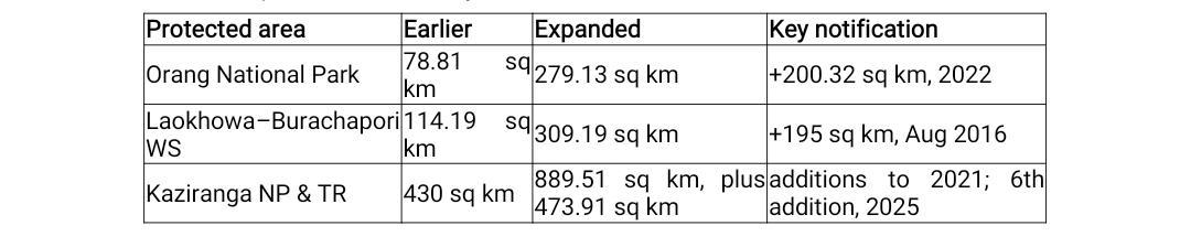
The material circulating in defence of Assam's conservation credentials makes the ecological case against the proposal. Between 2016 and 2025, the protected-area network expanded dramatically:
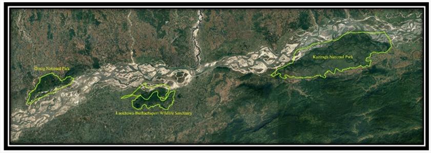
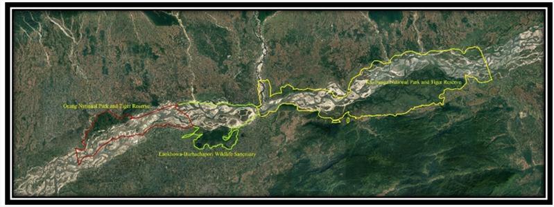
Satellite comparison of the floodplain before and after shows three separated islands of protection resolving into something nearer a continuous corridor. This is creditable, provided one distinguishes creation from expansion: Laokhowa dates to 1979, Burachapori to 1995, Orang to 1999, Kaziranga's protection to 1908. But the justification was connectivity — the Wildlife Institute of India treats Orang as part of the wider Kaziranga landscape, and the 2021 additions were argued as linkages towards Karbi Anglong and Nameri.
One cannot invoke connectivity to add 473.91 square kilometres and then define the surrounding buffer as though connectivity stopped at the pillar line. Nor is it coherent to withdraw the preliminary notification for Kaziranga's ninth addition in Sonitpur in June 2025 — 2,570 hectares proposed in 2020 for precisely the Nameri linkage — while claiming landscape conservation as an achievement. Least coherent of all: the ₹6,950-crore Kaziranga Elevated Corridor, with 35 kilometres of elevated wildlife passage, is being built to restore permeability across a highway, and required diverting roughly 20 hectares of core-zone land and 365 hectares of eco-sensitive zone land to do it. Having spent core habitat to buy permeability at the road, it is hard to justify giving that permeability away at the quarry.
Whose restrictions are being eased?
The 2023 relief was granted for a specific figure: the villager who cannot rebuild after a flood, the anganwadi that cannot be built, the farmer needing a Conservator's permission to keep farming. That is the case the government invokes, and in the Mising settlements it is a real case.
It is not obviously the case the proposal serves. The most contested structure in the buffer today is not a village home but a proposed five-star hotel at Inglay Pathar, some two kilometres from the park, on agricultural land long cultivated by Adivasi tea-tribe families; Pranab Doley of the Greater Kaziranga Land and Human Rights Protection Committee was arrested in July 2026 over protests against it. A buffer loosened for hotels and quarries, while the households in whose name it was loosened continue to face eviction, is not a compromise between development and conservation. It is a transfer.
Which is where balance must become specific. The 2011 Guidelines already supply the architecture: prohibited, regulated, permissible. A household rebuilding after a flood, a school, a dispensary and a municipal stadium are not the ecological equivalents of a stone crusher or a resort. Assam could deliver every civic project the Chief Minister listed without touching the regulatory reach that governs extraction, simply by zoning activity rather than distance. That it has chosen instead to argue about kilometres is itself informative.
The Ministry itself annexed a working model. The Sultanpur notification (S.O. 191(E) of 27 January 2010), attached to the 2011 Guidelines as Annexure-3 for the guidance of every state, fixes a five-kilometre zone and then grades restrictions inside it by activity and distance: no construction within 300 metres, nothing above two storeys between 300 and 500 metres, no new high-tension transmission wires within 500 metres, no mining or crushing within one kilometre, a Zonal Master Plan prepared within a year, and a monitoring committee reporting annually. Note what that structure does. It reaches five kilometres out to catch quarrying and crushing, while permitting agriculture, tube wells and ordinary building at modest distances from the boundary. A Kaziranga zone built on the Ministry's own template would prohibit almost nothing a household in Bokakhat wants to do, and would still reach the Karbi Anglong quarries that a one-kilometre line releases.
So, it is prudent to delineate by watershed and corridor rather than distance, completing the CEC-mandated drainage analysis and corridor mapping and letting those layers generate a variable-width boundary. The 2023 draft should be published, the new proposal and the land-use inventory before anything leaves Dispur, and treat the Rule 5 draft stage — sixty days for objections, with the wide publicity the Court directed in April 2023 — as consultation rather than formality. Besides, it is important to retain a wide regulated zone southwards across the Karbi Anglong catchments, where the Sixth Schedule division of authority between state and Council produced the enforcement vacuum the CEC documented. Further, the rights of ESZ residents should be settled, which no statute presently does, and compliance data should be reported quarterly.
The allegation that the proposal serves corporate mining interests remains an allegation and should be treated as one; but the burden of dispelling it lies with the government, and the way to dispel it is transparency, not indignation. Assam has spent a decade enlarging the protected-area map. Whether that enlargement becomes functional connectivity, or what conservationists call paper connectivity with habitats contiguous in an atlas and impassable on the ground, is being decided now.
Rhinoceroses and other animals do not read notifications. That is not a flourish; it is the whole policy problem in a sentence.
Sources
Central Empowered Committee. (2025, May 30). Report to the Supreme Court. Reported in PTI/Business Standard/Deccan Herald/The Tribune, June 4, 2025. Central Empowered Committee. (2025, March 20). Letter to the Special Chief Secretary, Environment & Forest Department, Government of Assam. Reported in The Assam Tribune, June 11, 2026.
Gauhati High Court. (2026, March 12). Jiten Engjai v. Union of India. https://indiankanoon.org/doc/186750022/
Government of Assam. (2023, November). Cabinet approval of draft ESZ notification for Kaziranga Tiger Reserve and adjoining protected areas, and of nine animal corridors. Reported in The Sentinel, November 25, 2023.
Government of Assam, Environment and Forests Department. (2025). Wildlife database; notification of the sixth addition to Kaziranga National Park and Tiger Reserve.
Ministry of Environment and Forests (Wildlife Division), Government of India. (2011, February 9). Guidelines for declaration of eco-sensitive zones around national parks and wildlife sanctuaries (F. No. 1-9/2007 WL–I(pt)). Issued under cover of letter from the Deputy Inspector General (Wildlife), Paryavaran Bhawan, New Delhi, to the Chief Wildlife Wardens of all States and Union Territories.
National Tiger Conservation Authority. (2018, April 20). Field-visit assessment. Reported in The Assam Tribune, August 17, 2026.
Supreme Court of India. (2022, June 3). In Re: T.N. Godavarman Thirumulpad v. Union of India and Ors. I.A. No. 1000 of 2003 in W.P. (C) No. 202 of 1995 (Bose, Gavai, Nageswara Rao JJ).
Retrieved from Indian Kanoon:http://indiankanoon.org/doc/159581452/
POST A COMMENT