Sikkim completes first comprehensive field-based study of high-risk glacial lakes for GLOF mitigation
Sikkim has completed a field-based study of nine high-risk glacial lakes to assess GLOF threats. The findings identify hidden vulnerabilities and outline practical measures for mitigation and early warning.

- Sep 03, 2026,
- Updated Sep 03, 2026, 6:57 PM IST

- Bathymetric surveys measured true lake depths and water volumes across sites
- Moraine dam scans uncovered saturated zones, buried ice and hidden seepage
- Khangchung Chho stored over 125 million cubic metres, dwarfing Lachung Khangtse
Sikkim has achieved a significant milestone in glacial hazard assessment by completing a comprehensive, field-based study of nine high-risk glacial lakes, strengthening efforts to understand and mitigate the threat of Glacial Lake Outburst Floods (GLOFs) in the Eastern Himalaya.
The study, conducted between 2022 and 2025, is among the first detailed ground-based assessments of multiple glacial lakes in the region. The findings have been published in the journal Natural Hazards in 2026.
The research was undertaken by scientists from the Sikkim Science and Technology Department, Sikkim University and partner institutions, with the objective of generating detailed, site-specific information that can support disaster preparedness and mitigation planning.
GLOFs occur when large volumes of water stored in glacial lakes are suddenly released, potentially causing destructive floods downstream. The threat has gained renewed attention across the Himalayan region following major incidents, including the South Lhonak Lake outburst in Sikkim in October 2023.
Unlike assessments based primarily on satellite imagery, the latest study involved extensive field investigations to examine the physical and geological characteristics of the lakes and their surrounding areas.
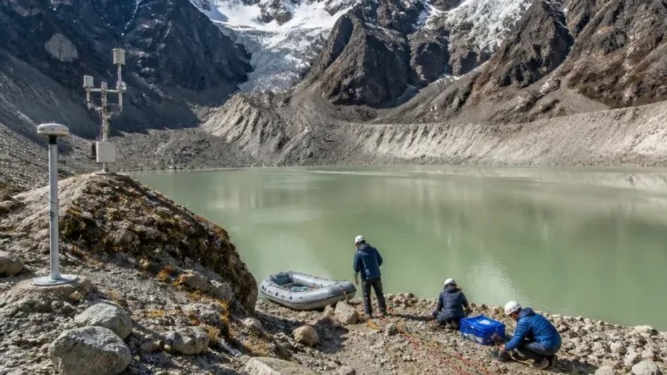
The researchers conducted bathymetric surveys to determine the actual depth and volume of water stored in the lakes. An unmanned surface vehicle was used to map the lake beds, providing information that was previously unavailable for several of the assessed water bodies.
The team also carried out electrical resistivity tomography surveys to examine the areas beneath moraine dams. These investigations helped identify potentially vulnerable features such as saturated zones, buried ice and concealed seepage channels.
The findings demonstrated that surface area alone cannot provide a reliable indication of the volume or potential hazard posed by a glacial lake. Two lakes with similar surface dimensions can contain significantly different amounts of water because of variations in the depth and shape of their basins.
Among the lakes studied, Khangchung Chho emerged as the largest and deepest, with a water volume of more than 125 million cubic metres. In contrast, Lachung Khangtse was found to be relatively shallow, holding less than two million cubic metres of water.
One of the significant findings came from Shako Chho, where subsurface investigations detected seepage channels several metres beneath the moraine crest. The channels were not visible through conventional remote-sensing observations, highlighting the importance of ground-based investigations in identifying hidden vulnerabilities.
Researchers estimated that reducing the water level of Shako Chho by around 20 metres could remove approximately 11 million cubic metres of stored water, thereby reducing the potential pressure on the moraine dam. A solar-powered pumping system has been proposed as one possible mitigation measure.
To strengthen early warning capabilities, an automatic weather station at Shako Chho is monitoring weather and lake-level conditions. The information can support disaster-management authorities in identifying changes that may require timely intervention.
The study has proposed a four-stage framework for GLOF risk reduction. The process begins with satellite-based screening to identify potentially dangerous lakes, followed by detailed field assessments. The third stage involves engineering design based on field findings, while the final stage focuses on implementing mitigation measures on the ground.
Researchers believe the approach could serve as a model for other vulnerable areas of the Hindu Kush Himalayan region, including parts of Nepal and Bhutan.
The study also highlights the need for further investment in advanced technologies such as drone-based LiDAR mapping and satellite radar deformation monitoring. Such technologies could help assess glacial lakes that are difficult to access because of terrain, weather conditions or cultural sensitivities.
The project assumes particular significance as the National Disaster Management Authority has identified 189 high-risk glacial lakes across the Indian Himalayan Region. Sikkim's field-based approach could therefore provide valuable information for moving beyond broad hazard identification towards targeted and practical mitigation measures.
The researchers stressed that effective GLOF preparedness requires close coordination between scientists, geologists, engineers and disaster-management authorities. Detailed knowledge of lake depth, water volume, moraine stability, seepage and surrounding hazards can help authorities design measures suited to the specific risks of individual lakes.
With climate change increasing concerns over the stability and growth of Himalayan glacial lakes, the study represents an effort to bridge the gap between scientific hazard assessment and on-ground disaster-risk reduction, with the ultimate objective of protecting downstream communities, infrastructure and livelihoods.