Assam: Geo bags deployed at Kongkur to combat erosion as flood situation remains critical in state
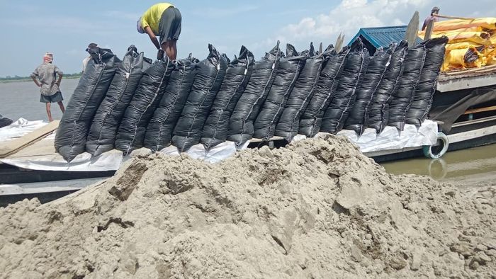
Assam Water Resources Minister Pijush Hazarika on July 20 said that the government has started deploying Geo Bags (Type-B) under the flood drill programme to control dangerous erosion along the riverbank in the Kongkur area. These geo bags have been sourced from the Central Materials Bank and are being placed to prevent further land loss in one of the worst erosion-prone regions in the state.
- Jul 20, 2025,
- Updated Jul 20, 2025, 5:16 PM IST
Assam Water Resources Minister Pijush Hazarika on July 20 said that the government has started deploying Geo Bags (Type-B) under the flood drill programme to control dangerous erosion along the riverbank in the Kongkur area. These geo bags have been sourced from the Central Materials Bank and are being placed to prevent further land loss in one of the worst erosion-prone regions in the state.
“The erosion situation at Kongkur is alarming. We have begun placing the geo bags received from the Central Materials Bank. This is a necessary step under our flood preparedness plan,” said the minister.
Meanwhile, the state continues to reel under heavy flooding, with many major rivers flowing above danger levels in several districts. According to the official flood bulletin issued by the Assam Water Resources Department on July 20 at 8:00 AM, the Brahmaputra River is showing alarming levels at multiple locations.
At Dibrugarh, the Brahmaputra is currently at 106.48 meters, surpassing the danger mark of 105.70 meters. Similarly, in Neamatighat (Jorhat), the river is flowing at 87.37 meters, which is significantly higher than the danger level of 85.54 meters. In Tezpur, the Brahmaputra is also above safe levels, flowing at 66.59 meters against the danger mark of 65.23 meters.
Other rivers are also witnessing a sharp rise. The Lohit River at Dholabazar in Tinsukia is flowing at 130.07 meters, well above its danger level of 128.27 meters. The Gainadi, Jiadhal, and Buridihing rivers in Dhemaji and Dibrugarh districts have also shown rising trends, raising concerns of possible breaches and flooding in low-lying areas.
In districts like Lakhimpur, Dhubri, Goalpara, and Barpeta, multiple rivers including the Subansiri, Ranganadi, Dikrong, and Beki are either rising or have crossed the threshold danger levels.
The situation is also troubling in South Assam. In Cachar, Hailakandi, and Karimganj, the Barak, Katakhal, and Kushiyara rivers have either crossed or are nearing their danger marks. For instance, the Barak River at A.P. Ghat is at 21.84 meters, far above the danger mark of 19.83 meters.
Minister Hazarika said that all departments are working in close coordination. Relief camps have been readied in flood-prone districts, and boats and emergency teams are on standby. “We are monitoring the situation every hour. Our top priority is to save lives and reduce damage to property and agriculture,” he said.