Guwahati waterlogging woes: Assam-Meghalaya join hands on satellite mapping
Assam and Meghalaya agree to use satellite mapping to tackle Guwahati's flood waterlogging. Both states seek a balanced solution protecting economic interests and environment.
- Jun 03, 2025,
- Updated Jun 03, 2025, 8:20 AM IST
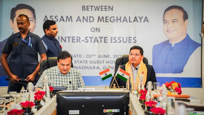
As waterlogging looms large in Guwahati amid floods, the Assam and Meghalaya governments on June 2 announced a joint decision to adopt satellite mapping.
It is worth mentioning that the Assam government has been blaming Meghalaya for illegal hill-cutting activities that have contributed to waterlogging.
The solution would also focus on ways that would "not disrupt economic activities" of the people of Meghalaya, the chief ministers of the two states said at a press conference here after discussing issues of mutual concern.
They will urge the North Eastern Space Applications Centre (NESAC) for the mapping and then approach IIT-Roorkee with the data to find a solution involving the best interests of both sides, Assam Chief Minister Himanta Biswa Sarma and his Meghalaya counterpart Conrad Sangma said.
“The government of Assam gave a detailed presentation to the Meghalaya team on how we are getting huge quantity of water from Khanapara area in the inter-state border along Guwahati,” Sarma said.
Sangma, noting that the floods were a ‘major concern’, said, “In the last few days and months, we have seen how rain is playing a role in view of climate change. Challenges are more than before, and both states have to work together.” Sarma and Sangma said both states have decided to work on a solution which will minimise the problem of waterlogging in Guwahati and also safeguard the interests of Meghalaya, without impacting the economic activities of the state.
For this purpose, they will jointly approach NESAC to carry out satellite mapping of Guwahati and its adjoining areas, including forest cover, water flow, waterlogging, etc, and submit the data within three months.
The information will be provided to IIT-Roorkee to analyse it and come up with a solution for the inter-state project, Sarma and Sangma added.
Since last year, Sarma has been blaming hill cutting in Meghalaya for worsening waterlogging problem of Guwahati, which lies in the downstream of Ri-Bhoi district of the hill state.
He had held a privately owned University of Science and Technology, Meghalaya (USTM), responsible for “flood jihad” against Guwahati, claiming that the water flowing down from the varsity campus, which is located on a hill adjacent to the city, leads to massive flooding.
Sarma had also said that his government has approached a Supreme Court committee regarding the hill-cutting issue, and the apex court has already issued notices to both the state in the matter.