Guwahati's hills under threat: 366 landslide-vulnerable sites identified
A comprehensive survey of 366 landslide-vulnerable sites across Guwahati has revealed that the overwhelming majority of slope failures are linked to human activities rather than natural causes, highlighting the growing impact of unplanned urban development on the city's fragile hill ecosystem.
- Jun 15, 2026,
- Updated Jun 15, 2026, 1:53 PM IST
A comprehensive survey of 366 landslide-vulnerable sites across Guwahati has revealed that the overwhelming majority of slope failures are linked to human activities rather than natural causes, highlighting the growing impact of unplanned urban development on the city's fragile hill ecosystem.
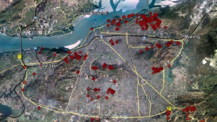
The study identified vulnerable locations across 20 areas, including Fatasil, Garbhanga, Gotanagar, Hengerabari, Jalukbari-Lankeswar, Kahilipara, Kalapahar, Kamakhya-Nilachal, Khanapara, Kharguli, Koinadhora, Maligaon, Nabagraha, Narakasur, Narengi, Noonmati, Santipur, Sarania, Sukreswar and Sunsali. Among these, Kharguli recorded the highest number of vulnerable sites with 77, followed by Noonmati (40), Narengi (37), Khanapara (33), Maligaon (31) and Jalukbari-Lankeswar (30).
The assessment found that 95 per cent of landslide-prone locations are the result of man-made factors, while only 5 per cent are attributed to natural causes. This indicates that activities such as hill cutting, construction on steep slopes, inadequate drainage systems and unregulated urban expansion are the primary drivers of slope instability in the city.
Analysis of slope inclination showed that 88 per cent of vulnerable slopes have an inclination of up to 60 degrees, while 7 per cent exceed 60 degrees and 5 per cent are classified as negative slopes. Regarding slope height, 57 per cent of the identified sites have heights of less than five metres, followed by 20 per cent between five and ten metres, 18 per cent between 11 and 15 metres, and 5 per cent exceeding 15 metres.
The study also examined slope conditions and vegetation cover. Nearly 45 per cent of vulnerable slopes were found to have no vegetation cover, making them more susceptible to erosion and failure. Another 36 per cent had grass and bushes, while only 19 per cent had tree cover, which generally provides better slope stability.
In terms of geological composition, 62 per cent of the vulnerable slopes consist of a combination of rock and soil, 34 per cent are composed solely of soil, and only 4 per cent are made up entirely of rock.
A major concern highlighted in the report is that 74 per cent of the identified sites require immediate intervention to prevent loss of human lives and property, while only 26 per cent require comparatively lesser attention.
To facilitate monitoring and planning, all surveyed locations have been mapped and superimposed on Google Earth, providing a visual representation of landslide hazard zones across Guwahati. The mapping offers authorities a comprehensive overview of vulnerable areas and can support disaster preparedness, mitigation measures and urban planning efforts.
The findings underscore the urgent need for stricter regulation of hill cutting, improved drainage infrastructure, afforestation programmes and scientific land-use planning to reduce landslide risks in Assam's largest city.