'Satellite imagery proves it': Ex-Manipur CM defends anti-poppy drive amid deforestation reports
Former Manipur Chief Minister N Biren Singh has strongly defended his administration's destruction of illegal poppy plantations, asserting that satellite imagery vindicates the state government's environmental claims against widespread scepticism.
- Jun 06, 2025,
- Updated Jun 06, 2025, 11:25 AM IST
Former Manipur Chief Minister N Biren Singh has strongly defended his administration's destruction of illegal poppy plantations, asserting that satellite imagery vindicates the state government's environmental claims against widespread scepticism.
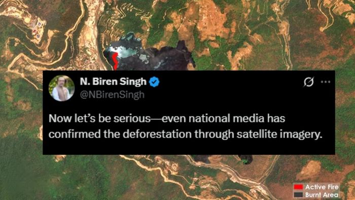
"Now let's be serious—even national media has confirmed the deforestation through satellite imagery. Many people didn't believe the State Government's claims. But the facts speak for themselves," Singh stated in a social media post today.
The former CM emphasised his government's anti-drug operations, claiming they destroyed over 18,000 hectares of illegal poppy plantations between 2017 and 2025. "From 2017 to 2025, the State Government has destroyed over 18,000 hectares of illegal poppy plantations—a massive effort to combat drug trafficking and prevent deforestation," he said.
The former CM's statement comes as new satellite data from Suhora Technologies highlights critical environmental challenges facing Northeast India. The Earth observation company's analysis reveals alarming deforestation rates in Manipur, with Global Forest Watch data showing approximately 17,800 hectares of natural forest lost in 2024 alone, releasing nearly 9.11 million metric tons of carbon dioxide.
Suhora's comprehensive study spanning 2021 to 2025 indicates Manipur lost around 21,100 hectares of forest during this period, with only 13 hectares showing signs of regrowth. The research points to multiple factors driving forest loss, including unsustainable traditional shifting cultivation practices, illegal logging, fuelwood collection, and the spread of poppy cultivation in remote hill areas.
Infrastructure development projects, while improving regional connectivity, have also contributed to deforestation and increased landslide risks in Manipur's fragile mountainous terrain. Climate change has compounded these environmental pressures by altering rainfall patterns and increasing vulnerability to wildfires and pest infestations.
The satellite technology has proven crucial for monitoring environmental crises across the region. Recent analysis detected a significant forest fire in Arunachal Pradesh's Nadipar region near Dirang in West Kameng district on April 24, 2025. Using advanced machine learning algorithms and daily PlanetScope satellite imagery, researchers identified that 1.09 square kilometres of forest burned, with 0.03 square kilometres remaining active as of April 26.
Krishanu Acharya, CEO of Suhora Technologies, stressed the importance of satellite-based analytics for providing near-real-time insights that support rapid response to environmental crises. He acknowledged that while deforestation figures remain concerning, recorded vegetation regrowth offers hope for recovery through sustainable land-use practices and community-based forest management.