Land-use changes degrading water quality of rivers feeding Loktak Lake: Nagaland University
Changes in land use, including agriculture, settlements, and shifting cultivation, are directly degrading the water quality of rivers feeding into Loktak Lake — one of India’s most iconic freshwater ecosystems and a designated Ramsar Site in Manipur — threatening both biodiversity and the livelihoods of local communities, a study by Nagaland University has found.

- Oct 27, 2025,
- Updated Oct 27, 2025, 5:47 PM IST
Changes in land use, including agriculture, settlements, and shifting cultivation, are directly degrading the water quality of rivers feeding into Loktak Lake — one of India’s most iconic freshwater ecosystems and a designated Ramsar Site in Manipur — threatening both biodiversity and the livelihoods of local communities, a study by Nagaland University has found.
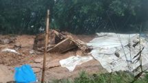
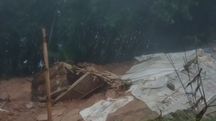
Loktak Lake, home to 132 plant species and 428 animal species, supports hydropower generation, fisheries, transport and tourism. However, in recent decades, the lake has been listed under the Montreux Record — a global warning list for wetlands undergoing serious ecological damage. Reduced fish populations, rising pollution levels and increased sedimentation have emerged as major concerns.
A Ramsar Site is a wetland designated to be of international importance under the Ramsar Convention on Wetlands, signed in 1971 in Ramsar, Iran. Such sites are recognised for their ecological significance, particularly for supporting biodiversity and providing critical habitat for waterfowl.
The study, published in the International Journal of Environment and Pollution, highlights pressing environmental challenges arising from agricultural runoff, human settlements and shifting cultivation that are directly affecting river water quality in the region.
“The study confirms that agricultural runoff, settlements and shifting cultivation in the Loktak catchment are directly degrading river water quality, with the Nambul and Khuga rivers emerging as the most polluted due to high land-use disturbances,” said Jagadish K. Patnaik, Vice Chancellor, Nagaland University.
Also Read: Loktak hydroelectric project faces logistics hurdles, NHPC briefs Manipur Governor
To understand the root causes, researchers at Nagaland University conducted field sampling across nine major rivers — Khuga, Western, Nambul, Imphal, Kongba, Iril, Thoubal, Heirok and Sekmai — that drain into Loktak Lake.
Using detailed Land Use Land Cover (LULC) maps, the team compared different types of land activities such as agricultural areas, dense and degraded forests, settlements, jhum cultivation and water bodies against water quality indicators like dissolved oxygen (DO), biological oxygen demand (BOD) and temperature.
“Our study confirms that land-use decisions across villages and forest landscapes upstream are directly impacting water quality downstream. This makes community-based land management and stricter control of agricultural runoff and waste discharge crucial for restoring Loktak Lake,” said Eliza Khwairakpam, Assistant Professor, Department of Environmental Science, Nagaland University.
“Land management is not just an environmental concern but also a livelihood protection strategy for the people of Manipur. Catchment-wide land regulation, sustainable agricultural practices and controlled jhum cycles will be vital for protecting India’s only floating national park and the endangered Sangai deer habitat within the lake,” she added.
The Nambul River was identified as the most polluted, with low oxygen levels and high organic contamination — directly linked to 47 per cent agricultural land and 11 per cent settlement areas in its sub-catchment. The Khuga River showed the second poorest water quality despite higher forest cover, which researchers attributed to extensive jhum (shifting) cultivation recorded at 42 per cent in the region.
In contrast, rivers such as Iril and Thoubal, which flow through forest-dominated landscapes, displayed better water quality, highlighting the protective role of natural vegetation.
The research was supported by the Forest Department, Government of Manipur, which provided LULC maps, and the Manipur Pollution Control Board, which assisted in fieldwork.