Historical Records Debunk Narratives That Kukis Were Not Under Maharajas of Manipur
It is unsurprising that, even in 2025, certain Kuki leaders—such as those in SoO Agreements—persist in attempting to fabricate a new history for the early 1900s, an era richly documented by colonial records, administrative reports, and official correspondence.
- Nov 11, 2025,
- Updated Nov 11, 2025, 5:26 PM IST
It is unsurprising that, even in 2025, certain Kuki leaders—such as those in SoO Agreements—persist in attempting to fabricate a new history for the early 1900s, an era richly documented by colonial records, administrative reports, and official correspondence.
Their recent assertions that Kukis were never under Manipur but instead fell directly under the administration of a British Political Agent represent a blatant distortion.
These new storytellers insist that their ancestors lived beyond the reach of the Manipur Maharaja, answering only to a distant British Political Agent in some mythical “Excluded Area.” This is not interpretation. This is forgery. It is a deliberate, documented lie that misleads schoolchildren, poisons researchers, and fans the flames of separatism.
What is deeply concerning is how these groups mislead their own communities, young researchers, and historians with such fabrications. Ample historical evidence from the princely state of Manipur unequivocally debunks these claims.
To begin with, the very presence of Kuki plantations in Manipur explodes the myth of eternal separation. Under the visionary policy of British Political Agent Colonel William McCulloch, Maharaja Nara Singh boldly granted frontier lands to incoming Kukis as early as 1844—strategically settling them in Manipur’s exposed Naga borders to fortify the kingdom’s defenses. During the Lushai Expedition alone, a staggering 649 Mizo captives were liberated and resettled under the Maharaja’s benevolent rule.
This was no isolated act: a massive influx of 2,112 refugees—373 Sukte, 957 Paite, 110 Soomtie (Paite vassals), and 612 Mizos—fled persecution and sought sanctuary beneath Manipur’s protective crown, planting roots in the Thangjing range, an inseparable swathe of the state’s southwestern hills and valleys. The 1881 census lays bare the truth: Manipur’s Kuki population stood around 25,000, with 8,000 “Old Kukis” (tribes like Chiru, Purum, and Anal, integrated since the 16th century) and 17,000 “New Kukis”—all settled, governed, and taxed under the Maharaja’s sovereign authority. These were not autonomous migrants; they were subjects of the crown, their plantations proof of Manipur’s inclusive dominion.
Also Read: Toward a Scandal-Free Manipur Civil Services Examination 2022
The colonial archives and treaties tell us that every Kuki village, every pine ridge, every bamboo grove paid tax, bent knee, and drew breath under the sovereign crown of Manipur. To deny this is to spit on history and sabotage peace.But in 2025, the assault on truth has escalated from words to wanton destruction.
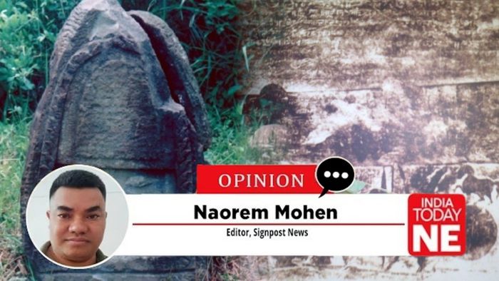
Reports from the hills—whispers turned to alarms—reveal a chilling pattern: the targeted erasure of stone inscriptions that stand as eternal sentinels of Manipur's unified sovereignty. These monoliths, etched with royal edicts and victory proclamations, dot the landscape from the western fringes to the Indo-Myanmar border. They proclaim the Maharaja's dominion over hills and valleys alike, including Kuki-inhabited territories.
Yet, amid the ongoing ethnic strife, certain actors—emboldened by separatist rhetoric—have plotted their obliteration. The Pamheiba stone in Pherzawl district, the Chibu stone at Behiang in Churachandpur, and others like them are not mere rocks; they are irrefutable witnesses to a shared past. To topple them is to dynamite the foundations of reconciliation.
Let the records speak. Let them roar. And let us rage against this planned desecration, for it is the final, furious act of those who would rewrite history with hammers and hate.
Kuki groups want you to forget this treaty. They must—because it buries their myth six feet under. And now, they eye the stones that echo its legacy, plotting to shatter them before they can testify. Manipur's hills are not barren; they are inscribed with the kingdom's unyielding claim. These victory stones—Langam Nung in the royal tongue—were raised by Maharajas to mark conquests, boundaries, and authority. They stretch from Cachar to the Chindwin River, a chain of granite decrees binding valley to hill. Planned destruction, whispered in militant camps and amplified by CSO agitators, threatens to erase them.
Why? Because they dismantle the separatist fable. They prove Kuki lands were never autonomous; they were integral to the crown's realm, policed, taxed, and defended under one banner.Take the Pamheiba stone, perched atop the Bangai Range in western Manipur's Pherzawl district. Erected in 1734 by the warrior-king Pamheiba (Garibniwaz), it commemorates his triumph over Tripura Kingdom (Takhel) who invaded Manipur. The inscription, facing east like a defiant sunrise, details the weapons of Manipuri troops: spears, shields, and swords wielded by Meitei and hill allies alike.
The Cheitharol Kumbaba, Manipur's royal chronicle, corroborates every glyph: Pamheiba camped there, asserted dominion, and left this marker of sovereignty. It is a hill stone, proclaiming Manipur's reach. Colonial explorer Sir James Johnstone sketched it in the 19th century, preserving its ferocity for posterity.
No less endangered is the Chibu stone at Behiang, near the Indo-Myanmar border in Churachandpur—a Kuki stronghold scarred by conflict. Installed in 1872 under Maharaja Chandrakirti Singh, it celebrates the Lushai Expedition's success, where 2,000 Manipuri troops—under British oversight but royal command—pacified frontier raiders. Reports from Behiang speak of "planned removal" under cover of chaos, to bury claims of Manipur's hill sovereignty. Chibu is not just stone; it's a border post of unity. Shatter it, and you sever the hills from the kingdom that forged them.
These are not isolated threats. Kohima's Gambhir Singh stone (1832), Tipaimukh's boundary markers, and four ancient edicts near the Indo-Myanmar frontier—from 6th-century Meidingu Urakonthouba to 19th-century Maharaja Gambhir Singh—all whisper the same truth: Manipur's crown encompassed the hills. Now, these boundary stones mysteriously "disappeared".
Kuki leaders that peddle "Excluded Areas" lies now graduate to physical vandalism. This is cultural genocide by chisel—destroying proofs of taxation, Lallup labor, and Darbar petitions from Kuki villages. It mocks the Gazetteer of Manipur (1886), where Captain Dun mapped these stones as sovereignty's spine. It insults McCulloch's 1867 ledger, where hill lands yielded rent to the Raja. To tolerate this is to license anarchy.
Manipur's sovereignty did not emerge in isolation; it was forged through centuries of resistance and diplomacy. As early as 1762, the Anglo-Manipuri Treaty between Maharaja Jai Singh (Bheigyachandra) and the British East India Company affirmed the kingdom's independence. This pact, rooted in mutual trade and cultural exchange, recognized Manipur as a buffer state against Burmese incursions, not a subordinate territory. The treaty's spirit endured, even as British influence grew. This very treaty shows in between Manipur and Burma, no other kingdom exist.
By the 19th century, Manipur's Maharajas exercised absolute proprietorship over land, forests, and people—a system documented meticulously in colonial records.Consider the Annual Reports of the Manipur Political Agency. In 1867, Colonel William McCulloch, the Political Agent, reported to the Government of India: "The Raja is the absolute proprietor of the soil, and can dispose of it as he likes. No one is prohibited from cultivating, but rather the contrary, for every male who comes on duty is entitled to cultivate one pari of land, paying a rent for the same." This was no abstract feudalism; it was a regulated agrarian order.
Subjects, including those in the hills, received cultivation rights in exchange for service and rent. McCulloch's account, preserved in British archives, underscores that land was not communally owned by tribes but vested in the crown. Kuki villages in regions like Churachandpur, Henglep, Thanlon, Tamenglong, and Chandel were integral to this system, paying house taxes and petitioning the Darbar for redress.
The 19th-century British accounts shatter any illusion of fragmented rule in Manipur: the kingdom's strategic police posts—Thannas—formed an iron grid of sovereignty across hills and valleys, binding every frontier under the Maharaja's unyielding command. Clair Grimwood vividly observed, “At every five miles the Manipuris had Thanahs to keep a lookout against enemies, and acting as stages for the dak-runners,” a testament to Manipur's proactive defense network.
Captain E.W. Dun's 1886 Gazetteer meticulously catalogs these outposts, from the compact Chakpi post in the Yumadoung hills—nine miles from the Kabo Valley pass—to the fortified Chattik stockade in Tangkhul territory, garrisoned with a Subedar, Jemadar, Havildar, bugler, and sixty sepoys. Jiri, erected post-1833 Treaty on the Assam border; Kalanaga atop western ranges to repel Lushai incursions; Kangkum in Phungyar and Khoupum on the Imphal-Cachar road, bolstered to fifty sepoys by 1868–69 against Lushai threats—these were no mere symbols but active enforcers of order, revenue collection, and border security.
This web extended relentlessly: Kongal on the Namsangki River spur, vulnerable yet rebuilt after Burmese-backed attacks in 1877; Mao on the Imphal-Dimapur road, established 1873–74 with fifty sepoys to counter Naga raids; Moreh and Noutong on Yumadoung's eastern flats, each with Subedar-led forces of forty-plus; Numlon under Chandrakirti Singh, manned by two hundred sepoys against Kamhow assaults in 1855–56; and Prowl northeast of Tangkhul lands with fifty sepoys.
Numerous additional police posts were established in Manipur's hill regions, including Kala Naga Thanna, Kangbam Thanna, Karong Thanna, Keithelmanbi Thanna, Mayangkhang Thanna, Namfow Thanna, and Yangoupokpi Thanna, among others. These posts were structured into three concentric defensive circles centered on Imphal, which served as the core. The Inner Circle featured posts at key valley locations. The Middle Circle comprised Kangkum Thanna, Karong Thanna, Keithelmanbi Thanna, Khoupum Thanna, Mayangkhang Thanna, Mombi Thanna, and similar outposts, strategically positioned between the central valley and the encircling hills. The Outer Circle included Jiri Thanna, Mao Thanna, Kongal Thanna, Chattrick Thanna, Yangoupokpi Thanna, Moreh Thanna, Chakpi Thanna, and Numfow Thanna, among others, placed at vital border points to secure Manipur's frontiers.
These were not ornamental; they were garrisoned with officers and sepoys—dozens, sometimes hundreds—maintaining order and collecting revenue. Lambus, or revenue officials, operated in hill villages, ensuring compliance. Even forced labor, known as Lallup, drew from hill tribes, including Kukis, for infrastructure and defense.This administrative mesh extended to judicial and economic spheres.
The Manipur State Administration Report of 1936–37 explicitly places Kuki villages under the South-West Subdivision, subject to Darbar orders and taxation. Petitions from Kuki chiefs reached the Maharaja's court, resolving disputes over land or succession. Far from being "outside" Manipur's sovereignty, these communities were woven into its fabric.
The self-defeating logic of the Kuki's “Excluded Areas” claim is stark: by insisting their ancestors inhabited such zones, they unwittingly confess outsider status to Manipur itself. No Excluded Area ever lay within Manipur’s borders; the real ones—Lushai Hills, Naga Hills, Garo Hills and the unadministered Burma frontier tracts—sat firmly outside the kingdom. Manipur was absent from this list. It remained a princely state, internally autonomous under the Maharaja, with Britain handling only foreign relations. The entire territory—valley and hills—was the Darbar's domain. Claims of direct Political Agent rule ignore this distinction; the Agent advised, but the Maharaja governed.
These were wild, loosely governed corridors where Thadou-Kuki clans and other migrants drifted across porous frontiers throughout the 19th and early 20th centuries. In clinging to this label, the Kuki CSOs tacitly concede that their forebears arrived from what is now Mizoram’s Lushai Hills, trekked in from Nagaland’s Naga Hills, or slipped over from Burma’s Chin Hills and Somra Tracts. British records seal the admission: T.C. Hodson in 1908 called the Thadou Kukis “recent immigrants… many clans came from the south (Lushai) and east (Burma)”; J. Shakespear in 1912 documented waves entering Manipur after the 1830s, fleeing Burmese tyranny or chasing arable land; and the 1931 Manipur Census plainly tagged numerous Kuki clans as “new immigrants” settled in the hills only with Darbar consent.
Meanwhile, the forest management provides perhaps the most compelling evidence of unified sovereignty. Manipur's forests were not wild commons but sovereign assets, managed for revenue and conservation. In 1833, Maharaja Gambhir Singh's treaty with the British secured the Jiri-Barak drainage forests, ceding Cachar in exchange. These became economic lifelines, leased for timber, cane, and wildlife products.
By 1907, the "Rules of Management of the State of Manipur" formalized the Manipur State Darbar—a proto-cabinet of eight members under the Maharaja. This body oversaw administration, justice, and resources. British officers like W.A. Cosgrave and A.J.W. Milroy documented vast reserves: pine forests, river catchments, and bamboo groves.
The Heingang Reserve Forest, notified in 1913, marked the Darbar's early conservation efforts—reserves declared not by imperial fiat but royal policy.In 1933, D.C. Kaith, a forest officer deputed from Assam, submitted a comprehensive plan to the Darbar. He divided the Jiri-Barak forests into 19 timber blocks for auction, emphasizing scientific management.
Kaith stated plainly: "Ownership of forest lay with the Maharaja, management was carried out by the Forest Department of Assam on behalf of the Manipur State Darbar, and income was shared in the ratio of 75% to the Maharaja and 25% to the Forest Department of Assam." This 75-25 split was no concession of sovereignty; it affirmed the crown's primacy, even under British oversight.
From 1898, Manipur leased forests to entities like the Burma Trading Corporation in Rangoon. By the 1930s, Cane Mahals and monopolies on non-timber products were auctioned statewide. Villages retained usage rights, but ownership was unequivocal: the state's. This balanced stewardship with livelihood, predating modern environmentalism.
The culmination came in 1946, amid post-war transitions. F.F. Pearson, Political Agent and President of the Manipur State Darbar (Hill), adjudicated F. Misc. Case No. 294 of 1945-46. Kuki villages claimed independent rights over timber and firewood across vast tracts. Pearson rejected this outright: "It was totally wrong that Kuki villages should claim the rights over timber and firewood over vast areas. Such areas belong to the State and not to the villagers."
To mitigate hardship, he introduced annual licenses—free of charge—allowing sales of forest produce, provided hillsides were not burned. Violations meant cancellation. This order was a definitive assertion: forests were state property, licenses mere privileges under the Maharaja's (and now transitional) administration.Pearson's ruling echoes through the decades, refuting modern distortions.
Kuki areas were policed, taxed, and resource-managed by Manipur's apparatus. No "direct" British rule severed them from the Darbar; the Political Agent interfaced with the Maharaja, not bypassing him.Yet, history's ironies abound. The Apex Court's 1996 ban on timber auctions nationwide dismantled Manipur's ancient system, subsuming it under central regulation. What was once royal wealth became national oversight, fading memories of the Maharaja's stewardship.
Today, as Manipur grapples with separation narratives by some communities, these records demand reckoning. From the Anglo-Manipuri Treaty of 1762, McCulloch's 1867 report, Dun's 1886 Gazetteer, Kaith's 1933 plan, the 1936–37 Administration Report, and Pearson's 1946 order form an unbreakable chain. They prove the Maharaja's sovereignty over land, forests, and peoples—including Kukis. Villages paid house taxes, manned Thannas, contributed lallup, and petitioned the Darbar. Forests yielded revenue to the crown, not autonomous tribes.
Against this backdrop, contemporary assertions by certain Kuki civil society organizations that they were never under the Manipur king or administration collapse under the weight of documented history. These records demonstrate beyond doubt that the Maharaja’s sovereignty extended over land, forests, and people alike, and that attempts to rewrite this past are not only misleading but a disservice to the truth.
Reconciliation is not possible on lies. Separate electorates, separate homelands, separate histories—these are the fruits of forgery. The hills and valley share one crown, one ledger, one destiny. Denying this will not empower Kukis!